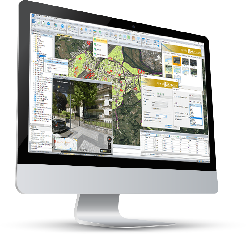
Einfache und schnelle Bearbeitung der
räumlichen Daten im GSTARCAD
Spatial Manager für GstarCAD ist ein leistungsstarkes GstarCAD
Plug-in, entwickelt für die Anwender, die auf eine einfache, schnelle und kostengünstige Weise die räumlichen Daten in CAD-Programm importieren, exportieren und bearbeiten müssen.
Spatial Manager für GstarCAD

Spatial Manager ™ ist als eigenständiges Programm oder als Plug-in für GstarCAD und andere CAD-Plattformen erhältlich. Es handelt sich um ein leistungsstarkes CAD-Plug-in, entwickelt für die Anwender von AutoCAD-a oder GstarCAD-a, die auf eine einfache, schnelle und kostengünstige Weise die räumlichen Daten importieren, exportieren und verwalten möchten. Dies umfasst viele Optionen, die in den CAD-Programmen bisher nicht verfügbar waren.
Es ist in einer leichten Applikation verfügbar, die innerhalb des CAD-Programms funktioniert und dem Anwender das Importieren und Exportieren von Geodaten zwischen den CAD-Zeichnungen und Geo-Dateien, Datenservern oder Datenspeichern, die Anzeige der Karten im Hintergrund und die Verwaltung der alphanumerischen Daten und Datentabellen ermöglicht.
Hauptmerkmale
IMPORT von räumlichen Daten in GstarCAD
Importieren Sie die räumlichen Daten in die neuen oder bestehenden DWG-Zeichnungen als GstarCAD-Objekte und erweiterte Entitätsdaten (Extended Entity Data – EED).
Mehrsprachigkeit
Verfügbar in Englisch, Deutsch, Spanisch, Französisch, Russisch und Portugiesisch
EXPORT von räumlichen Daten aus GstarCAD
Exportieren Sie die Objekte aus der Zeichnung in die räumlichen Dateien oder Datenbanken und speichern Sie deren erweiterten Entitätsdaten (Extended Entity Data – EED) als Tabellen mit den alphanumerischen Daten.
Karte als Hintergrund
Wählen Sie aus vielen dynamischen Karten von Anbietern wie Google Maps, OpenStreetMap, Bing, MapBox, Ordnance Survey usw. aus oder konfigurieren Sie Ihre eigenen Karten aus den TMS-, WMS- oder WMTS-Servern.)
Koordinatentransformation
Berechnen Sie die geometrischen Transformationen von Objekten beim Import und Export.
Rechner für Felder
Berechnen Sie einfache oder komplexe Ausdrücke mithilfe von Operatoren und Funktionen, die auf die Feldwerte in einer Tabelle und/oder auf konstante Werte angewendet werden können.
Thematische Darstellungen
Visualisieren Sie die Objekte, indem Sie diese entsprechend ihren Feldwerten einfärben.
Veröffentlichung auf Google Earth
Export von allen oder einem Teil der Objekte in den sichtbaren Ebenen der Zeichnung und deren Daten in eine KML- oder KMZ-Datei
Terrain
Erstellen Sie das 3D-Gelände und ähnliche Objekte (3D-Punkte, Konturen usw.) aus den 3D-Daten oder aus den Elevation-Leistungen.
Datenverwaltung
Verwalten von alphanumerischen Daten, die den Objekten beigefügt sind, Entwerfen und Bearbeiten der Struktur, die zum Speichern der Daten verwendet wird.
Datenraster
Sie können mit der Datenrasterpalette die Objektdaten in jeder Tabelle in der Zeichnung anzeigen, bearbeiten usw. Außerdem können Sie Objekte aus dem Datenraster auswählen, Daten aus Tabellen exportieren usw.
Markierungen der Objekte
Fügen Sie die Datenwerte aus den Tabellen zu Objekten in der Zeichnung hinzu und markieren Sie diese als Texte.
Aufgabenimport
Speichern Sie die Aufgaben, um die Importvorgänge (einschließlich aller Prozessparameter) beliebig oft zu wiederholen.
Räumliche Analyse
Führen Sie die Vorgänge der räumlichen Analyse für die Objekte in der Zeichnung durch und generieren Sie so die neuen Objekte aus dieser Analyse.
Dauerlizenz
Zahlen Sie einmal, keine wiederkehrenden Gebühren
Standort-Tools
Die Standort- und Geokodierungstools helfen beim Hinzufügen von den Referenzelementen und erweiterten Daten zu den vorhandenen Objekten.
Google Street View-Integration
Dynamischer Bildbrowser Google Street View für jede georeferenzierte Zeichnung oder Karte
Basic Edition
Standard Edition
Professional Edition
Hauptmerkmale
Import spatial data into GstarCAD
Imports spatial data, into new or existing GstarCAD drawings, as GstarCAD objects and Extended Entity Data (EED)
Multilanguage
Available in English, German, Spanish, French, Russian and Portuguese
Export spatial data from GstarCAD
Export objects from the drawing to spatial files or databases, and saves their Extended Entity Data (EED) as alphanumeric data tables
Import spatial data into GstarCAD
Imports spatial data, into new or existing GstarCAD drawings, as GstarCAD objects and Extended Entity Data (EED)
Coordinates transformation
Calculate geometric transformations of the objects in the import and export processes
Fields calculator
Calculate simple or complex expressions using operators and functions that can be applied to field values in a table and/or to constant values
Thematic maps
Visualize objects coloring them depending on their field values
Publishing to Google Earth
Export all or part of the objects in the visible Layers of the drawing and their data to a KML or KMZ file
Terrains
Create Terrains and other related objects (3D Points, Contours, etc.) from 3D data or from Elevation services
Data management, query and edition
Manage the alphanumeric data attached to the objects, design and edit the structure which will be used to store the data
Data grid
The Data Grid palette allows you to view, edit, etc. the objects data in any table in the drawing. You can also select objects from the Data Grid, export the data from the tables and more
Label objects
Label data values from tables attached to the objects as Texts
Fields calculator
Calculate simple or complex expressions using operators and functions that can be applied to field values in a table and/or to constant values
Spatial analysis
Perform spatial analysis operations over the objects in the drawing generating new objects from such analysis
Perpetual license
Pay once, no periodic fees
Location tools
Location and geo-coding tools help to add reference elements and enhanced data to existing objects
Google Street View integration
Google Street View dynamic image browser on any geo-referenced drawing or map
Basic Edition
Standard Edition
Professional Edition
Spatial Manager Tutorial Videos:


